About Us
The Division of Environmental Geosciences investigates key processes controlling the natural environment and anthropogenic impacts. Researchers at EDGE combine field observations with experimental work, linking molecular-scale mechanisms at environmental interfaces with complex large-scale environmental processes using quantitative modelling. At EDGE, we accept the challenges posed by the release of known and emerging pollutants and recognise the need to understand their impacts on soils, ground and surface waters, using process-based and mechanistic research.
News
25.04.2024

16.04.2024

05.03.2024

EDGE Lecture Series


Publications
Chaudhuri, S., Sigmund, G., Kumar, N., Hüffer, T., Mautner, A., & Hofmann, T. (2024). The efficacy of Pb, As(V) and Sb(III ) removal by biochar is determined by solution chemistry. Environmental Science: Water research & technology, 10(4), 912-921. https://doi.org/10.1039/D3EW00726J
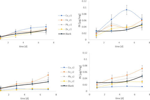
Bubl, M., Heinz, P., Wanek, W., Schagerl, M., Hofmann, T., & Lintner, M. (2024). Impact of heavy metals (Cu, Fe, Pb, Zn) on carbon and nitrogen uptake of the diatom-bearing benthic foraminifera Heterostegina depressa. Heliyon, 10(6), [e27229]. https://doi.org/10.1016/j.heliyon.2024.e27229
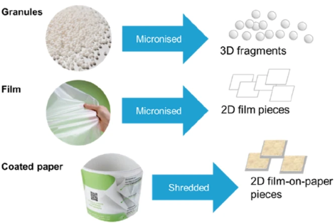
Pfohl, P., Rueckel, M., Meyer, L., Battagliarin, G., Künkel, A., Hüffer, T., Zumstein, M., Hofmann, T., & Wohlleben, W. (2024). Influence of plastic shape on interim fragmentation of compostable materials during composting. Microplastics and Nanoplastics, 4, [7]. https://doi.org/10.1186/s43591-024-00084-8
Jachimowicz, P., Peng, R., Hüffer, T., Hofmann, T., & Cydzik-Kwiatkowska, A. (2024). Tire materials disturb transformations of nitrogen compounds and affect the structure of biomass in aerobic granular sludge reactors. Journal of Hazardous Materials, 465, [133223]. https://doi.org/10.1016/j.jhazmat.2023.133223
Walch, H., Basic, N., Praetorius, A., von der Kammer, F., & Hofmann, T. (2024). A versatile test system to determine nanomaterial heteroagglomeration attachment efficiency. Environmental Science: Nano, 11(2), 588-600. https://doi.org/10.1039/D3EN00161J